CSC News
Developing a System to Assist the First Responders and Law Enforcement Agencies
Dr. Muhammad Shahzad, assistant professor in the Department of Computer Science at NC State University, and research assistant, Usman Khan, have developed a system that generates maps of buildings without entering the building.
 “Our
project includes wireless-transmission equipment that uses radio frequencies.
We set this equipment outside a building and it does a sweep of the entire
building,” Shahzad said. “By looking at the reflection of the signals that come
back from objects within the building, we can take this information and
construct a map of the insides of the building.”
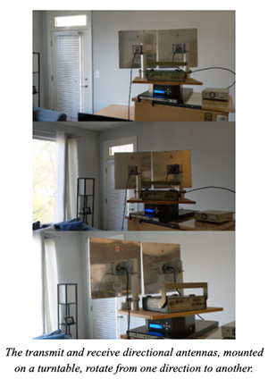
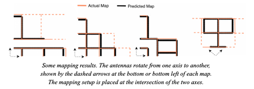
The team has designed a setup consisting of transmit and receive antennas that can be placed outside a building to generate its map. Once the setup is in position, the antennas rotate to scan the parts of interest of the building and measure the distances of different obstacles in the building using signal processing techniques. This setup operates at the frequencies of a few GigaHertz, and at these frequencies, the walls and other indoor reflectors do not diffuse reflections in all directions. This means that the antennas receive reflections from only a few parts inside the buildings. This sparse information about the distances of different obstacles does not directly translate to complete maps. To overcome this challenge, the team developed intelligent machine learning approaches that take the information about sparse reflections as input and generate the map that best fits the sparse reflections.
According to Shahzad, this technology offers multiple benefits as it allows individuals to see the layout of a building before entering inside. Additionally, Khan adds that law enforcement and first responders would benefit greatly from this technology.
“First responders could use this technology at the scene to know what the building looks like inside, locate the different victims, and allocate their resources accordingly.”
Shahzad said that first responders and law enforcement agencies inspired the idea for the project. After having discussions with fire departments and police departments regarding the need for a device that could generate maps without requiring personnel to enter a building, the team began to develop a solution that could make the operations safer for these agencies.
 The
project can currently generate maps of buildings for up to three levels of
walls. However, in the future, the team hopes to increase the project’s ability
to generate maps past three levels. Additionally, Shahzad and Khan plan to
upgrade the project so that it has the capability to locate entryways inside
the building and pinpoint the exact locations of people, who may be trapped
inside those buildings.
This work is supported in part by the US Army Research Office, under contract #W911NF-19-C-0009.
~snyder~
Return To News Homepage